From a thesis on the geology and mechanics of the slide at http://thesis.library.caltech.edu/691/" is this explanation.
Blackhawk Mountain, a resistant mass of marble thrust northward over uncemented sandstone and weathered gneiss, rises above southeastern Lucerne Valley at the eastern end of the rugged 4000-foot escarpment that separates the San Bernardino Mountains on the south from the Mojave Desert on the north. Spread out on the alluvial apron at the foot of the mountain is the Blackhawk rockslide, a lobe of nearly monolithologic marble breccia 30 to 100 feet thick, 2 miles wide, and nearly 5 miles long. At least two earlier similar but smaller rockslides have occurred in the area.
The rocks of the area comprise late Tertiary and Quaternary fanglomerates and breccias derived mainly from the gneiss, quartzite, Carboniferous marble, and Cretaceous quartz-monzonite of the San Bernardino Mountains. Uplift of Blackhawk Mountain occurred in two stages after deposition of the older fanglomerates and breccias: the first by over-thrusting from the south, and the second by monoclinal folding along a northwest-trending axis.
Geological evidence in the area shows that the Blackhawk rockslide traversed the gently inclined alluvial slope as a nearly nondeforming sheet of breccia moving more than 50 miles per hour. The hypothesis that compressed air, rather than water or mud, constituted the lubricating layer on which the breccia sheet slid qualitatively explains all of the principal physical features of the slide lobe. Theoretical analysis of the flow in the lubricating air layer indicates the quantitative feasibility of the air-lubrication hypothesis for the Blackhawk slide.
Contest #568:
Rules, tips and previous WoGEs are collected by Felix on his http://woge-felix.blogspot.ca/ blog with a KML file available with all WoGEs.
#3, #2 and #1- depending on what you measure and when.
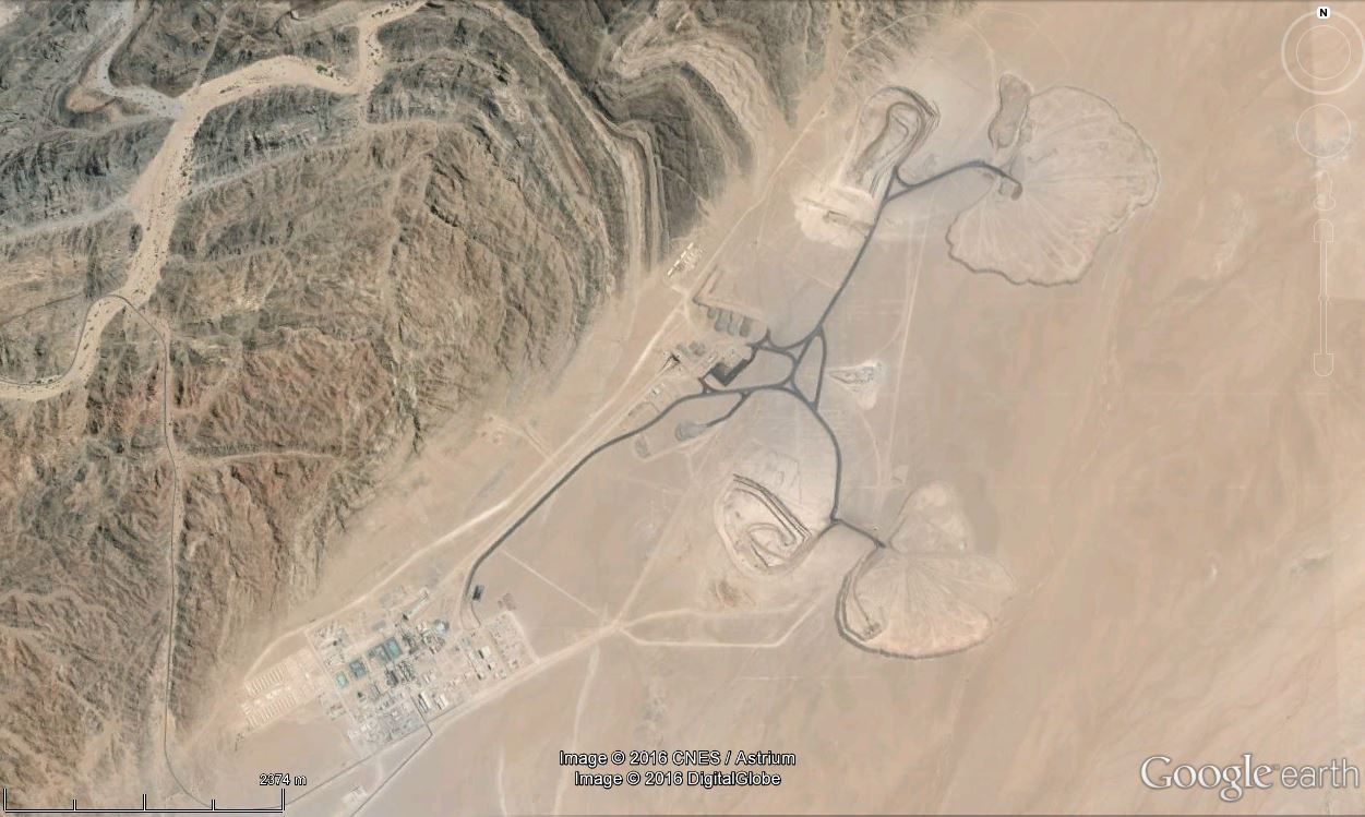
ReplyDelete22.6167°S 14.8833°E
ReplyDeleteHusab Uranium Mine, Erongo, Namibia.
"The Husab Mine, also known as the Husab Uranium Project, is a uranium mine under development near the town of Swakopmund in the Erongo region of western-central Namibia. The mine is located approximately 60 kilometres from Walvis Bay. The Husab Mine is expected to be the second largest uranium mine in the world after the McArthur River uranium mine in northern Saskatchewan, Canada and the largest open-pit mine on the African continent. The Husab Mine is to start production in early December 2015 after completion of the sulfuric acid leaching plant."
Geologically speaking the ore is hosted in sheeted leucogranites intruding metasedimentary rocks with the Khan-Rossing boundary acting as a redox front.
It was harder to find out what it is, than to find the location. The large area covered by various kinds of processing plants steered me in the right direction.
Ole... you are correct. The problem was identifying the place, and we came up with the same thing.
ReplyDeleteMy hint referred to the facts that you identified plus the fact that it was the 3rd largest uranium deposit in the world.
http://overburdenblog.blogspot.no/2016/05/woge-569.html is up.
ReplyDelete